I've made it to mile 906 and am in Mammoth Lakes, CA. My last resupply at Kearsarge Pass didn't leave me enough time to do a write up of the section but I have time now. You have to realize that every time I get to town I'm planning for a 5 to 7 day backpacking trip in the space of a few hours. Laundry, showers, dinner, food shopping, organizing, packing and planning all take time and these blog posts are secondary to all of that. I'm actually writing this from a hotel computer but staying at a campground since the library is closed and all the hotels are booked or double their normal price due to some motocross race in town. If they don't figure out I'm not a guest here I'll post a write up of the last section and possibly pictures.
I rolled into Kennedy Meadows with the idea of taking three days off to let my body recover for the Sierra Nevada's. I also knew my brother was going to visit but the area lacked any cell phone coverage so I could only get to him by email which he answered in typical California style (infrequently and vaguely) so I didn't know when he would get there or where he would be. The town is not really a town, just a general store and some vacation and ranch homes. One of those happens to be Tom's Place, a hiker centered compound of ancient RV trailers, an amphitheater and outdoor kitchen all wrapped inside an expansive nine hole disc golf course. There were easily thirty or forty other hikers staying there which made for good times. The general store had all the ice cream, beer and burgers a hiker could eat. Chris got there on Saturday afternoon with his lady friend Clio so we went for a swim at the Kern River just half a mile away from "town" and went on a tour of Tom's place to meet my hiker trash friends. The long stay let friends I had passed catch up, including Magic Mullet aka Teen Wolf aka Thunderdome who has to end his hike early in 200 miles and get back to school. We hiked together from before Mt Laguna (mile 43!) through Big Bear until I took a few more days off and didn't see him until Walker Pass, just fifty miles earlier. I thought I would see him on the trail the day we both left but I must have gotten too early a start. Sorry man! The next day was a long winding drive up a mountain to 9,500 feet (Bald mountain?) to see an active fire tower and view Mount Whitney, the tallest mountain in the lower 48 (14,505 feet) and my next major destination. I had some fun on the drive down and we hung out the remainder of the day and hiked the 2 miles from town to the Kennedy Meadows campground for some awesome dinner. The following morning I had to return to the PCT after a delicious bacon and blueberry pancake breakfast.
Kennedy Meadows is considered the start of the Sierra Nevada's even though the foothills really started around Walker Pass about fifty PCT miles earlier. Even so, you're still in the desert and have to climb 4,500 feet in twenty miles before you really hit the alpine environment. Half way up I hit the South Fork of the Kern River with a sweet campsite and some friends who were out fishing for trout. I could either stop there for an easy day with friends or keep trucking to finally put an end to the desert and get into what's considered the most beautiful section of the 2,650+ mile PCT. The same drive to finally be done with the hot dry desert kept me moving and I camped alone, 18 miles in, near the top of the climb.
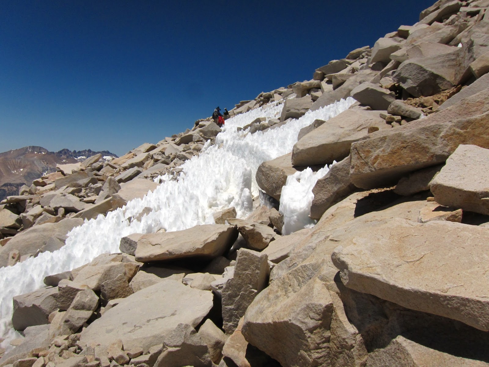
The next day I found myself hiking alone through a new alpine environment, past more water sources than 100 miles of desert hiking. It's an odd feeling to be so excited about something as simple as water and mountains. The next two days took me up to 11,500 feet, a new high altitude and left me gasping for breath on moderate inclines. On the way to Crabtree Meadow near the base of Mount Whitney I ran into a new group of hikers and we pushed out the last ten miles to our campsite for the next two nights. We would leave all our camping gear and most of our food at the base to take just clothes, water and snacks to the top. The mornings had been below freezing so we got a late start at around 8:45 to begin the 4,000 foot climb to the top of Whitney. Even after camping near or above 10,000 feet for the last three nights I felt like crap from the beginning. It could have just been nerves or the altitude but it felt like I only had one lung working. My three new friends took a long break three miles in and I decided to push on alone. At 12,000 feet the lack of oxygen felt even worse and I struggled to find a pace I could sustain without stopping frequently. At close to 13,000 feet I took my first real break to eat and drink. For some reason after that I felt almost normal and hauled ass up to the ridge that takes about 2 miles to slowly work its way to the summit. On the way I passed numerous John Muir Trail hikers starting or finishing their ~200 mile hike at the summit. Half a mile from the summit I started seeing familiar PCT faces who had left Kennedy Meadows the day before me but taken longer to get to Crabtree Meadows - Tee Cozy, Cream Tea, Piper and Crusty were all there. When I got in view of the hut on top of the summit I was so excited I actually ran the last 100 feet, not a great idea at that altitude. The views were incredible but the cold wind meant I had to change out of my wet clothes and put all the layers I brought with me on. I was amazed that the climb took just over 4 hours from lower Crabtree, it had felt like so much longer. The mountain is really just a big boulder covered lump, not what you would expect for the tallest peak in the 48.
The way down went easily but I learned one of my friends was leaving the PCT due to stomach troubles, possibly giardia. We took our time and camped together and he went south to the nearest trail exit. The next day I pushed on with Piper who had been hiking with Crusty and we made it over the tallest point in the PCT - Forest Pass (13,500 feet), catching Rustic along the way. The views were even better than Whitney and we met some sucessful through hikers from 2011, a record snow year where 90% of the trail in the Sierra was under 4 feet of snow or more! They were doing trail magic at the next meadow which gave us a good end destination for the day. The way down from forester pass takes you into Kings Canyon National Park which is probably the most amazing part of the trail. You hike into a narrow forested canyon with huge granite peaks on both sides of you that have near vertical sides and snow packed into crevices. We all made it to the trail magic at Vidette Meadow and had a great time eating the provided pasta and candy and telling stories. Someone left a toy sheriffs hat there so I did an impression of a hick sheriff patrolling the John Muir Trail ripping up hiker permits. I told the two guys doing the magic I would carry the hat at least to Sonora Pass - about 300 miles.
The next morning was a steep climb up to Kearsarge Pass, an exit point off the PCT. You have to hike 7.5 miles off trail with a 2,000 foot climb up to 12,000 feet or so just to get a resupply. Tee Cozy, Piper and I had a hard time hitching to Bishop for Resupply so I didn't have time to write this up then. We split a fancy hotel room but Piper had to stay an extra day for an important package since it was Saturday. I also got screwed since my bounce box was there but I couldn't get to it or mail it forward. I am screwed yet again since I got here at Mammoth Lakes on a Saturday and can't get mail again...
Tee-Cozy and I started hitching back to the Kearsarge trailhead at 9:45 the next morning but didn't get to the trail until 2 PM! I booked it up over Kearsarge and over Glenn pass to camp at Rae Lakes but that's for the next post. Maybe I'll write it up later.