In early May a CMC ski friend, Kristen, contacted me about skiing a 14er in the San Juans. I didn't think the snow would be very good on the easy route and the harder route was probably over my head since I haven't skied since March. She agreed and liked my idea of snow climbing Little Bear - what's generally known as the most dangerous Colorado 14er. The standard route ascends a narrow couloir with a funnel covered in baseball to bowling ball sized rock. Any rocks kicked down by climbers or mountain goats above are sent hurtling into the couloir and onto the climbers below. I had been wanting to climb it this time of year since there are fewer climbers on snow routes and the snow would reduce some of the rockfall. The governor had just given his okay to travel for "camping" as long as you don't spent time in the communities you travel through and plan ahead and Little Bear is in Alamosa county which has been applying for exemptions from the state COVID restrictions so we didn't feel unwelcome.
I met Kristen and we took her Xterra down - turned out to be the perfect vehicle for unrelenting rocks on the infamous Lake Como Road. In the right truck it really wasn't that bad, especially after airing down her tires to ~22 psi. This is a step most people miss when driving really rough roads; soft tires absorb bumps, conform to rocks to add traction and prevent sharp rocks from flatting the tire. You don't spin your wheels losing traction as much and can crawl more easily over difficult obstacles. It was mostly just rocks big enough to prevent a typical cross over from making it very far. We parked at 10,000 feet where the 14ers.com trailhead description said to park but could have made it another half mile. The hike in was slow, loaded with overnight packs, cold weather clothes, ice axes, crampons, etc. but we caught up to a local family out for a drive and day hike and chatted with them some.

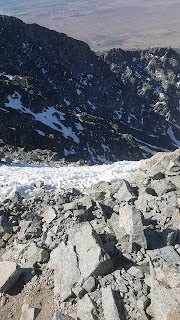
After 2.5 miles and about 1800 vert, we made it to Como Lake and found a site for the night in between snow drifts. The next morning we were hiking by 5:45. The route is fairly straight forward - ascend the snow filled North Gully, traverse along the ridge under the hourglass and then up to the summit. The lower half of the North gully was filled with rotten snow and it really slowed our progress. About midway up the snow was supportable and we were able to climb out to ascend to the hourglass.


The terrain above the hourglass was loose but not in a way that made me afraid of falling, just incredibly aware of how easy it was to send rocks down at frightening speeds. I was glad we were the only ones on the route but was still careful not to kick anything down on Kristen. We made it to the summit after nearly three and a half hours for a distance of 3.5 miles.


Soon we were descending and post-holing our way back to the tents. The route was so steep there was no real way to glissade anything so we ended up downclimbing, facing into the slope and using both axes for balance when the inevitable thigh deep plunge through rotten snow occurred. Eventually we were back at the tents for a short break and to pack our things for the walk out and long drive home.