Sunday, June 29, 2014

Overnight to the Bonds, South Twin and Galehead - aka a Semi-Pemi

This post is part of my training for my upcoming year of through hiking to support the people that help make the AZT, CDT and Te Araroa possible!  Please consider donating or sharing on facebook!

This past weekend AMC friend Chris and I headed up to the White's for a quick and light overnight trip.  On the menu was Bondcliff, Mount Bond, West Bond, South Twin, Galehead, down to thirteen brook tent site and then the bushwack up to Owls Head on the way out.  This would check off five mountains from my NH48 list, and bag South Twin for the second time - the first was on a training hike for the PCT over a year ago.  It's also the second half or so of a Pemigewasset Loop - the #2 hardest day hike in the country according to backpacker magazine (although I don't believe anything else they say so why believe that?).

Unfortunately, last weekend I spent a bit too much time on the mountain bike at Nembafest and triggered an old knee injury since I haven't been riding much.  I took the week off and it felt fine on Friday so I figured what the heck, let's go for it, it's only 20 miles the first day, twelve or so on Sunday and I hate cancelling last minute. Chris wanted to practice ultralight camping too, so I decided just to go for it.

We started out at 8 am at the Lincoln Woods trail head with a full parking lot and quickly made the 2.6 mile former rail bed walk into the Pemigasset Wilderness, crossed the bridge over Franconia Brook and continued our walk, dotted with "wilderness ties" - my name for the rail road ties left by logging crews in the late 1800's that cleared almost all the trees in the Whites - including the now "wilderness" area's.  We even spotted a wilderness bucket!

Bridge over Franconia Brook - which uses 1800's era foundations from a defunct logging railway


I don't mean to hate on wilderness area's, I certainly appreciate the preservation effort but it's a bit silly when trail crews aren't allowed to use chainsaws but reach their trails via former logging roads.

Politics aside, we made great time up to Bondcliff in under four hours and got some obligatory photos:
Bondcliff - appropriately named

Showing off!
We made our way up the ridge in the back of that last photo - Mount Bond and enjoyed the 360 degree views of just about every range in the White's.  My knee was bugging me a bit but not getting any worse, so I didn't worry about it.  Next up was South Twin, where we met four people in a row doing the pemi loop (you could tell by the death stares) and enjoyed the view back to Mt. Bond:

The knee really started bothering me on the rocky 0.8 mile 1,200 foot descent down to Galehead hut, so we took a longish break at the AMC hut, then a quick slack pack four tenths up to Galehead and back - probably a dumb idea just to check a box on a list.  We decided to just camp at the first decent spot on the way down to the Thirteen falls tent site and considered skipping Owl's head.  Meanwhile at the hut a woman doing the AMC Hut Traverse stopped by for some hut food.  The Hut Traverse is a 54 mile hike in under 24 hours to all 7 AMC huts usually done by trail crew members or the hut staff - totally insane!  Not only that, she only had 12 miles to go and it was 5 pm!

After the superwoman left we made our way down the thirteen falls trail.  Around halfway of the 2.6 mile trail I spotted a decent flat spot off trail with a small stream running by.  I hadn't been filtering water all day and gladly continued the practice.  Then we made camp - each with tarps.  My original plan for bug protection was a DIY bug netting supported by my hiking umbrella.  Sadly my tarp pitch was a few inches too short for the umbrella but there were so few bugs I just went without:
In the trees, all you need is a tarp... and maybe DEET
This was actually my first night under an open tarp (the gray one is mine).  The low pitch was pretty annoying, I think the A frame would only be comfortable with an 8 foot wide tarp instead of my 5 footer.  Next time I'll try a different pitch.  Otherwise it was nice to have such a light shelter, mostly for dew in this case.  Finding and breaking the sticks I used for support was a little annoying though.

I keep that tarp in my day pack as an emergency shelter, along with the gossamer gear nightlight pad for pack structure.  It's nice to be able to overnight if needed with only a pound and a half of added weight to an already sub pound daypack (MLD Burn) - lighter than most traditional empty day packs!  For this trip I was using my new-to-me Six Moon Designs swift pack - a smaller version of the Starlight I used on the PCT and sadly out of production.  I really like the pack and the lack of hip belt padding didn't become an issue. I keep my sleeping bag and jacket fluffed inside the pack to take up space, so the pack rode well to boot. I did notice the rear mesh pocket is significantly smaller than the Starlight but it wasn't a problem.  I do need to try it with heavier loads for dry stretches on the AZT and CDT though.

Unsurprisingly after some 1,300 miles on the PCT without a stove I forgot to bring fuel...  My mac and cheese was begging for boiling water but my alcohol stove seemed useless.  I tried to and quickly lost patience with building a small wood fire and then remembered my 2 ounce bottle of hand sanitizer - gelled alcohol! The first inactive ingredient is water but man does that stuff burn!  I squeezed a full ounce onto my stove, lit it up and set the pot on.  Who woulda' thought that it boiled the water and was just enough to perfectly cook my macaroni.  That and a can of salmon made for a filling dinner.  Camping before the designated tent site also meant a quiet night and no bear or critter issues.  That basically sums up ultralight to me - improvise, avoid high use area's and use your noggin.

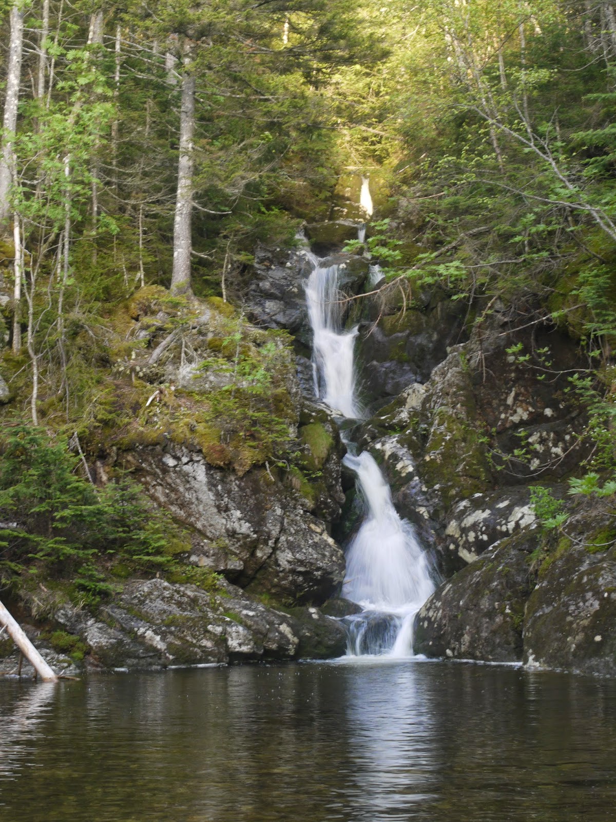
We slept pretty well, although I did put ear plugs in so Chris's neoair didn't wake me up every time he moved around.  The next morning my knee was really feeling stiff and sore so we decided to just head straight out instead of bagging Owl's head.  That meant 10 long flat miles out back to the trail head after pushing some leaves and brush back over our campsite and mixing the ashes from my pathetic fire attempt into the dirt.  We broke up the walk with some waterfalls and at one point next to a beaver pond were walking through more dragonfly's than I have ever seen - over a hundred of them all taking off around us!  They eat mosquito's and are in my opinion the coolest looking insect, so I was happy to see them.


Thirteen Falls fall waterfall number ??

Franconia Brook Falls up close and person

There were a bunch of water crossings on the way back and Chris got to try out getting his mesh trail runners wet and seeing how fast they dry.  This was his first hike with them instead of heavy waterproof boots and he seemed to love it, tripping less and actually having dry feet for a change.  He didn't realize how sweaty his boots would make his feet until trying the trail runners.  No ankle problems either - I think we've got a convert!


Base weight for the trip was a little under 9 pounds and not much different from what I plan on carrying for my upcoming through hikes aside from shelter choice, which I'm still working out.

All the other pictures are here: http://imgur.com/a/5ldd2

Friday, June 27, 2014

AZT Planning - Resupply!

This is part 2 of the planning posts for the first trail of my year of through hiking for the trails

The last post was water, without which in the desert you might last a few days.  Now that I have some notion of where the water will come from, the next step is food. I like to break food down by distance.  The easy math is simply divide the distance by how many miles you want to hike each day and pack for that many days.  Say the next leg is 115 miles and I want to do 20 miles a day so we can round up to 6 says. You might think if I leave town in the morning for a 6 day stretch, that means I need 6 dinners, 6 lunches, 6 breakfasts' and 6 days of snacks.  If you did, you'll wind up with an extra breakfast and dinner when you get to town!  If I can do 15 miles out of town today (day 1) I need one lunch, dinner and day of snacks.  The last day I won't need dinner since I'l be in town, and I ate day 1's breakfast in town.  Viola! Over a pound of food saved! How's that for ultralight? (yes I know I just wrote the musical instrument, it's a joke, lighten up).

Of course, this only works when you are certain about your pace.  If trail conditions are worse than expected, you were overly optimistic about your conditioning or you become injured and can't make your miles - you have to ration food, which is no fun.  The PCT had incredibly wonderful trail conditions with lots of other hikers. On the two or so occasions where I did start to run low on food, I bummed food from other hikers - I also gave away plenty of extra food.  The AZT is known for being more rugged and there likely won't be many other folks out to help out a hungry but foolish hiker low on food.  So for the AZT, most of the time I'll just carry the extra dinner and breakfast.  I can cut down on this by checking on the passage rating systems, so if a section is predominantly over easy passages I can just carry an extra lunch or snacks.

Notice the trend?  Uncertainty about water - carry more water.  Uncertainty about pace or trail - carry more food.

Here's my itinerary as of today.  Keep in mind I'll start the AZT after hiking the Wonderland Trail and doing a week of trail maintenance in the Goat Rocks Wilderness (more on that later).  Start off in Page, AZ with 4.5 days of food,  hike south, then...

Mile 727.7 - Hitch (illegal in Nat. Parks) or walk 2 miles to North Rim County Store - Pick up a box, spend a few days exploring the Canyon and possible Canyon to Rim to Rim with a friend from AMC (or just canyon to Rim if I'm lazy)
Mile 702 - South Rim - Pick up a box from AMC friend - carry 5 days of food
Mile 589.1 - Hitch to flagstaff via Hwy 89 for a zero and some grocery shopping for 6 days +/-
Mile 537.6 - Pick up some snacks n such at Mormon Lake Lodge, probably a meal
Mile 463 - Walk 1 mile off trail to Pine to buy food for 4 days or pickup a box, not sure
Mile 388 - Hitch 30 miles on Hwy 87 to Payson to buy groceries for 5 days
Mile 301.6 - Walk or hitch 2 miles East on Hwy 60 to Superior to buy for 5 days
Mile 200.8 - Hitch or walk 4 miles west on American Flag Rd to Oracle to buy food for 4 days
Mile 119.6 - Hitch or walk 5 miles on Colossal Cave Road to Vail - pick up a box at the post office for 3 days
Mile 52.8 - Walk into Patagonia, right on trail pick up a box at Mariposa Books and More for the last 3 days on trail

I like this resupply strategy since the hike is essentially book-ended by high quality boxed food, with the typical grocery store choices in the middle ~450 miles.  That means I won't get sick of either grocery store hiker food or boxed food, essential for the first leg of a year of backpacking.  It also means I need a maximum of 4 boxes for the whole trip, which won't take long to prepare.  The problem becomes maps - carrying 800 miles of paper maps kind of sucks - 45 pages in total - so 23 printed double sided.  It's not so much the weight or volume but the wear and tear and risk of loss.  That Brewery and Pub takes packages, so I may end up mailing 300 map miles there and including the last of them with my Vail box.

The next post will be navigation and how to get to/from the trail - stay tuned!

Friday, June 20, 2014

AZT - Planning Prep - Water

The Arizona Trail (AZT) is definitely one of the lesser hiked trails and in most cases is hiked in early spring or late winter, from south to north.  I will be hiking in early fall, north (Utah) to south (Mexico).  This complicates things because the guide books, water report and trail notes are all written for the opposite direction, six months earlier in the season.  But wait, there's more! Hiking in fall means fewer hikers on the trail and a slimmer margin for error.  Rather than relying on hikers ahead of me to report whether springs or streams are running, I'll have to wing it and assume only the most reliable sources are running, ask locals and carry extra water.  Not only that, the trail is broken up into passages, small pieces that make exploring sections much easier than on the PCT.  This is great for day users and section hikers/bikers but makes it a little difficult for me as a through hiker since there are 43 passages to keep track of - each with their own lists of data!

So how do you plan for such a badly timed, backwards facing hike?

Well it's not really that badly timed; Utah and parts of Arizona have a monsoon season of sorts through August and into September.  Depending on the year that will help the water situation.   Water sources are listed along the trail and rated by reliability, but these ratings seem to be largely based on spring, not fall conditions.  There are some caches along the route but they are even less reliable than the PCT.  The worse case scenario is renting a car for a day and caching water along the route.  If needed, I would probably do this in two steps, one before starting and one midway through.  Ideally it won't be necessary, and it wasn't for one of the hikers whose blog I've been reading - Buck30. The key will be keeping an eye on this years monsoon season and following the updates to Fred Gaudet's wonderful water report.  Even though I'll likely be the only southbound through hiker, hopefully the day and section users of the trail will send in some information ahead of me.  Not only that, but as of May it was expected to be a rainier than average monsoon season in Utah and Arizona according to NOAA - that great predictor of through hiker fates.

3-month precip outlook from May - I like that big green spot

Here's a sample of a random page of Fred' water report from June 20th:

Everything is organized by South to North miles, I'll be going North to South, which means lots of math in my head.  This section looks pretty good with even unreliable water mostly every 10 miles or less.  20 mile dry stretches will be ok as long as the heat stays low.  To carry it I'll have three 1L "smart" water bottles and a 2.5L platypus bag.  The bag is lighter than the bottles but having four containers makes for a good backup if the bag or any of the bottles leak.  For filtering and purifying I'll be using a sawyer squeeze in conjunction with the bottles.  Simply fill the bottles with dirty water and swap the cap for the sawyer and squeeze away.  The smart water bottles are more reliable than the squeeze.  I'll also take Aquamira as backup and for really gross looking water.

My usual formula for how much water to carry is:
Not Hot weather (80s or cooler): 6 miles per liter
Hot weather (90 or hotter): 4 miles per liter
Hot weather and climby (lots of elevation) - SIESTA!
           -Add 1.5L for dry camping

It served me well on the PCT with some night hiking thrown in.  The key is to know when to Siesta and not worry about time so much.  The worst is when it gets so hot you sweat in the shade, resting.  That is scary hot.

That about does it for water, check back next week on how I'll be planning food for the AZT.

Monday, June 16, 2014

Presidential Traverse Attempt with the AMC

Yesterdays lesson was don't believe the weathermen. We had already pushed the hike back a day to let the Friday and Saturdays rain clear out and forecasts predicted overcast skies clearing around 10 or 11 am, 30-40 mph winds near the summits.  Not perfect, but we expected to be out of the trees all day and were eager for views. Not hiking Saturday let our group of 24 AMC hikers (!) - 19 Southbound and 5 Northbound - spot the cars more easily, eat a big dinner and the southbounders catch an early nights rest at the newly reopened White Mountain Hostel in Gorham.  A 21 mile hike with just under 9,000 feet of elevation gain was on the menu for early Sunday morning.  The southbound presidential traverse hits Madison, Jefferson, Adams, Clay, Washington, Monroe, Franklin, Eisenhower and ending at Pierce.  The northbounders would add Webster and Jackson for an additional mile or two to the list.  This was to be excellent training for my upcoming year of through hiking.

A HUUUUGE thank you to the AMC leaders that organized this collossal undertaking, especially Pam, Joe, Jonathan and Alex!

The southbounders all drove about half an hour to the Appalachia parking lot, adjacent to the AMC highland center, leaving the lot by 5 am:
My camera time stamp of 4:38 AM


We took the Valley way path up to the Crawford trail - one of the oldest hiking trails in the White Mountains:
Steeps on the Watson Path

We could tell we had hiked out of the valley fog into a larger cloud system as we left the trees below.
Foulest weather on the world

Ascending past treeline around 8 am let the full force of the weather hit us - 30 to 50 mph winds blowing light rain and fog all the way up the rocky slopes of Mt. Madison, down and to Madison Spring Hut.  I didn't want to ruin my camera right off the bat so no photos of the wall of white we hiked through.  Visibility was down to 2-3 cairns at a time or less.  

"View" from Madison Springs Hut
Arriving in the hut many people realized the high winds had blown water straight through their rain jackets.  Once we all sat down everyone got cold, so it was a huge help to have hot drinks and snacks at the hut.  I got pretty chilly after a few minutes and a few folks were shivering. 

At this point the new forecast called for higher winds and more rain than we expected, with no definitive clearing during the day.  5 of the 19 southbounders called it a day and turned back to the Appalachia parking lot.  We wouldn't find out until reaching cell service at Mt. Washington that the entire team of northbounders had bailed at Mizpah Spring Hut just after Mt. Jackson.  It took an hour and a half to warm up and decide what to do.  The remainder of us decided to keep going for Adams and Jefferson and bail on various side trails if conditions didn't imrpove.  


Leaving the hut we seemed to climb out of the clouds, if only briefly.
Bits of blue sky heading up Adams


View of Madison Springs hut from midway up Adams.


  The rain seemed to cease and we were all able to dry out not long after leaving the hut. Unfortunately we would spend most of the day in and out of the fog. 


Hikers in the mist.
The fog would blow back, revealing the tops of the clouds and then roll in, or we would descend back into it.

Mount Quincy Adams
Trail dog Paprika!

Scrambling up Jefferson

Hopeful signs on the way to Mt. Clay


Joe and his 5 time NH48 summitting dog Paprika

Cog railway heading down into the clouds

Lake of the clouds hut


We summited Washington over an hour after we had planned.  Continuing on would mean arriving at the trailhead at 10 pm at the earliest and more than half the group was wearing thin.  The leaders decided to call it a day and head down the Ammonusic ravine trail to meet up with several of the hikers that bailed earlier.  A faster advance group left first to retrieve cars from the other parking spot area.  A big thanks to Pam for figuring all of that out.  We also learned the Northbounders hit bad weather like we had and turned around early, all along we were expecting to run into them and swap keys.  I was hitting my SPOT as we hiked along and they were able to follow our progress, despite the lack of cell coverage. As we descended Washington the views opened up and I finally got a glimpse of the Presidential range.  I decided to make a run for Monroe while the others kept descending.  One of our group - Nadiya joined me as we zipped down past Lake of the Clouds hut and up Monroe.

Monroe and Lake of the Clouds hut - ironically cloud free
I scrambled up Monroe a little ahead of Nadiya and hit the worst wind I've ever experienced.  I could barely stand up and Nadiya told me afterwards she had to crawl.   


Washington from the summit of Monroe

Washington finally clearing up

Heading down the Ammo trail

Waterfalls


Reunited in the parking lot.

We spent the next hour trying to figure out how to get everyone back to their car and reunited with their overnight bags - no easy task.  By 10 pm everyone was reunited and we were on our respective ways out.  A tough but rewarding day.  I'll have to come back and try for the full traverse again since I had done all but 800 feet of the elevation and had nothing but easy ridge walking left.  

Full photo album here: http://imgur.com/a/LTXJ2#0


The Next Big Hike

As soon as I got back from the PCT, people kept asking me "what's next?" wondering what I could do to top that.  My thinking at the time was that a new job, a new city, a new life.  Maybe that would do the trick and I could finally make a place for myself, long term, instead of the slow descent into boredom and wanderlust.  Conversely, the PCT seems to have had the opposite effect.  Before hiking, I always wondered about all the incredible places on the planet and if it was even possible for me to do a long hike.  After hiking, I know I can do it and I still wonder about all those places so it simply enabled me to think even bigger. At the same time, I was blown away that trails like the PCT even exist, that you can literally walk on a continuous trail for hundreds or thousands of miles! Imagine all of the effort required to build, maintain and negotiate access for that! So while I want to get back out there, I also want to give back.

Here's a rough plan:

September 4 - 11 - The Wonderland Trail (93 miles)

September 12 - 18 - Volunteer Trail work on the PCT in the Goat Rocks Wilderness

September 22 - Mid November - The Arizona Trail (800 miles) - AZT

Late November - Early April - The Te Araroa Trail in New Zealand (2,000 miles - think hobbits!) - TA

Early May - September - The Continental Divide Trail (2,500 to 3,000 miles depending on route choices) - CDT

That's right, I'm planning to go hiking for a year, including a week of trail work on the PCT.  Not only that, but I will be fundraising for the nonprofit organizations responsible for creating, maintaining and providing information about these trails!  The fundraising campaign is here: https://fundrazr.com/campaigns/fmYf1/ab/c3U9D9

Every year lots of folks hike for a cause and it's almost always an external one - cancer, lukemia, veterans, etc but without the trail those people would have no where to hike!  Few seem to stop and ask where the trail came from and how they can help make it better.  In the case of the CDT, the TA and AZT we can have a pretty huge impact on making these trails better.  They are still being established and better routes through private land are being negotiated or purchased.  The existing trail is often in need of improvement to make access safer and prevent erosion.  The money you donate will support projects to negotiate access across private land, extend conservation land, improve the trail tread and signage and help volunteer efforts for trail maintenance.  No one likes hiking on bushy, overgrown trail and private property rights always have to be respected.  Without these kinds of trail associations, we wouldn't have such incredible places to hike!  So even if you can't or don't feel the need to donate, please share the link on facebook, twitter, google +, whatever!  Just get the word out in the hiking community that the newest trails need help and we're the ones to do it!

I plan on taking a long break after (and possibly before) the Te Araroa to catch up with family and do some fast paced CDT planning since I can't really plan that far ahead.  I will have to keep things flexible and may not end up hiking 100% of all of the trails.  The end goal is to support the trail associations and get the word out about how amazing they are - not a speed record or continuous back to back to back through hike.

You can subscribe to my blog and keep up with updates on the fundraiser and my progress by typing your email in the "subscirbe by email" box at the upper left side of the screen.  Here's that fundraiser again!  https://fundrazr.com/campaigns/fmYf1/ab/c3U9D9


Monday, June 9, 2014

Day Hiker Extraordinaire

I'm sad to say that I haven't slept outside in several months.  I still hike frequently, generally every weekend but at the end of each day there's the car, the long drive home and the hot shower.  It's a very different mentality from through hiking.  Rather than a vague number of days to reach a road for a hitchhike with innumerable campsites in between, now I need a set course, a turnaround time, and time allotted for travel has to be incorporated.  Want to go for a 20 mile day hike? Better be up driving by 5 am and you won't be home until at least nine pm.  If it's winter, you'll be in the dark.

The other big change has been hiking with the Appalachian Mountain Club (AMC).  When I returned to "normal" life in my new city of Boston, I decided to make my outdoorsey activities more social.  AMC had a volunteer run winter hiking and backpacking program starting about a week after I began my new job, so I signed up.  I already knew most of what they were teaching but it was a good way to meet some folks and do some hikes I wouldn't have done solo.  The course culminated in an above treeline workshop with a winter summit of the highest peak in the northeast - Mount Washington.  We used crampons and ice axes to work our way up the remarkably steep Lion's Head route, then up to the summit in 40-50 mph winds but at a balmy 20 degrees.
Summit of Mount Washington in February


Afterwards, I hiked with an old friend-of-a-friend on a moosileake ski in and hike up and Osceola summit.  I alternated my time between winter hiking, XC skiing and snow biking on my new 4-inch wide tire'd fat bike - a Surley Pugsley.  This was an excellent winter for XC skiing, we had a solid month of weekly snow storms to build a solid base of snow and create perfect skiing conditions on the weekends. No fun for driving to work during the week but perfect for skiing!

By early May the snow began to melt and hiking up north meant post holing a slushy monorail all day, which is no fun so I kept to some lower elevation hikes.  I took the spring leadership class through the AMC and can now co-lead hikes, basically assist the leader with logistics and help make sure no one gets lost. One of the AMC leaders I had met, Pam invited me to a few hikes afterwards too.  We ate sandwiches (and lasagna) on the sandwich range and a week or two later did 12 out of 13 mini-peaks on an 18 mile day in the Belknap range.  I then co-led my first AMC hike with Pam and a few other leaders up Mt. Cannon in the White's.  It was a beginner hike, so we took the "fast" group and it was nice to see people who are new to hiking enjoying a perfect day up to their first 4,000 foot summit.
View of Franconia Ridge from part way up Cannon

Last weekend brought another, bigger, AMC day hike.  I originally hiked the northern 13 miles or so of the Wapack trail and back as a training hike for my PCT through hike but missed the southern 9 miles or so.  A while back I saw a trip listing with the AMC for a full day traverse - 21.4 miles and about 5,000 feet of climbing.  A single traverse like that isn't easy solo since you have to get back to your car somehow. Camping isn't allowed along the Wapack, except at the middle in a lean-to at my favorite XC ski spot which makes a two day out-n-back too long.  The single day traverse went well, and as usual there was the typical range of hiking speeds in our group of 12.  It seems no matter how accurate the trip description there are always a few who bite off a little more than they can chew, but there's nothing wrong with that if they don't mind losing the ability to walk the next day.  We had a slow start with too many breaks at the beginning but eventually things sped up after most of the climbing was done over North Pack Monadnock. I finished with the lead group at around 7 PM but we were waiting until 7:45 for the rest.  It was a good hike and I even met an AT 2012 through hiker who's aspiring to do the PCT in 2015, so it was fun nerding out about the PCT with her.

The Wapack was perfect training for this weekends big day hike - a Presidential Traverse.  We'll be going over 10 of the Presidentials in a 20.6 mile hike with 8,600 feet of elevation gain.  That may actually be more elevation than my biggest days on the PCT, which seemed to top out around 7,000 feet in a day but had more miles.  This is a highlight of hiking in the White's and I have barely spent any time in the Presi's, so I'm looking forward to it.

I don't plan on staying a day hiker for very long though.  I'm planning an overnight trip with a friend and another solo trip both in the Whites.  The next big trip is right around the corner as well...

Friday, June 6, 2014

Blowing the dust out

I originally put this blog together fairly hap-hazardly for my PCT through hike.  I just made some big design changes after doing some googling so they will be ongoing.  I moved the map of my PCT hike to the bottom a while back, now it's off the front page entirely.  Instead, it's been shifted to the PCT tab which you can access by the link up at the top of the page.  I'm trying to figure out how to make it more obvious that my blog has tabs, and I'll use them for future adventures.  Feel free to comment with ideas! I'm also giving Google Adsense a try. It probably won't generate much of anything but we'll see.